The Land Use Planning Commission's Adjacency Principle
After 14 minutes of discussion at its meeting on April 2, 2019, the Land Use Planning Commission (LUPC) voted to make one of the most sweeping policy changes in its history. In eliminating the one-mile adjacency policy, LUPC made close to one million acres of land in Maine’s Unorganized Territories (UT) vulnerable to development.
NRCM is deeply disappointed in the LUPC’s decision, which ignored overwhelming opposition from Maine people.
For more than 40 years, LUPC’s one-mile policy required new residential subdivision, industrial, or commercial development in Maine’s UT to take place within one road mile of existing, compatible development. Based on NRCM’s decades of watchdogging LUPC to protect forests and wildlife of Maine’s North Woods, we know that the one-mile policy served a critical role in effectively limiting fragmentation and sprawling development by requiring new development to reflect existing, on-the ground patterns.
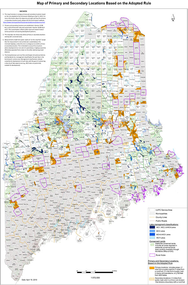
The new adjacency principle is displayed in the map above. There are now 39 rural hubs, and development is meant to be concentrated within a few miles of each in areas termed “primary and secondary locations,” which are represented by orange and striped, orange areas on the map, respectively.
What Changes to the Rules Did LUPC Make?
The Commission did make some limited changes to its Location of Development rules, including the adjacency principle, throughout the review process in response to thousands of comments in opposition to their proposal. However, we still have several concerns about the approved rules:
- Almost one million acres (close to 10 percent of LUPC’s jurisdiction in the UT) would be vulnerable to residential development. Residential subdivision development would be allowed on up to one million acres of forests and lakes (after subtracting out the lands that are already conserved).
- Commercial development would be allowed on close to 700,000 acres across the landscape and on an unknown number of lakes in LUPC jurisdiction. Given that commercial development under the one-mile rule could occur only near development of a “similar type, use, occupancy, scale or intensity” or near a “village center,” this is a significant change that could dramatically change the character of the UT and siphon economic development away from towns that want it.
- Allowing development along any public road within seven miles "as the crow flies" from the boundary of 39 “rural hubs” could lead to strip development. The seven mile by one mile primary development areas would allow commercial and residential strip development along currently forested, undeveloped roads (many of them scenic byways) and would undermine efforts by neighboring, rural communities to keep development within their towns as they attempt to enhance the economic viability of their local businesses.
- Allowing large lot subdivisions risks fragmentation of the North Woods. Sprawling large lot residential subdivisions, also called kingdom lots, were banned by the legislature in 2001. Under LUPC’s approved rules, large lot subdivisions (15-25 acre lots) would be allowed on hundreds of thousands of acres. Such sprawling development could displace or degrade large parcels of forestland.
Given that LUPC’s decision to eliminate the one-mile policy ignored many of the concerns raised by Maine residents, NRCM will pursue other policy mechanisms to protect the natural resources and character of Maine’s North Woods while also strengthening the economies of communities that are adjacent to LUPC’s jurisdiction.
Incentivizing developers to build in existing communities will help protect forests from fragmentation while maintaining wildlife habitat and migration corridors. Furthermore, the forests, lakes, and rivers that are the backbone of Maine’s forestry and outdoor recreation industries in the North Woods will be better protected when new development is not scattered throughout the mostly undeveloped UT.
Evaluation of the Effectiveness of the New Rules
The LUPC is charged with periodically evaluating the effects and effectiveness of the new Location of Development Rules. In September 2020, agency staff released a draft Work Plan describing the information they plan to collect to conduct the evaluation. Based on public feedback, including from NRCM, the LUPC updated the Work Plan, and the Commission approved it in January 2021. The Work Plan can be found here.
News clips during the rulemaking process that amended the Location of Development Rules in 2019:
- NRCM news release: LUPC Proposal Faces Overwhelming Opposition from Maine People, February 12, 2019
- LUPC’s second public hearing on the proposal was held on Thursday, January 10, 2019.
- Read NRCM's testimony, given by Forests & Wildlife Project Director Cathy Johnson.
- Read additional NRCM testimony on this proposal below in Additional Resources.
- Bangor Daily News op-ed by NRCM Forests & Wildlife Project Director Cathy Johnson, "With Proposed Development Rule Change, Maine's North Woods Hangs in the Balance"
- Bangor Daily News editorial, "Allowing Sprawling Development Would Hurt Towns, Wildlife and Wilderness"
- Portland Press Herald editorial, "Rule Paves the Way for Wrong Kind of Growth in Rural Maine"
Banner photo: Shoreline of Square Lake in Aroostook County. Photo by J.Monkman/NRCM


