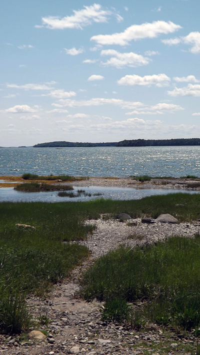
 At the town line between Brunswick and Harpswell on Route 123, a panoramic view opens out on both sides of the roadway, with historic farm structures flanked by wide fields leading down to tidal marshes and open water. These lands lie in the narrow isthmus at the top of Harpswell Neck, situated on a historic Native American portage site.
What was, for many local residents, a cherished and seemingly timeless landscape, came perilously close to becoming “Skolfield Farm Shores,” a subdivision with eight upscale houses. Fortunately, Harpswell Heritage Land Trust (HHLT) and community members rallied to conserve the threatened landscape and emerged with a larger plan that will ultimately protect 182 acres of farm, forest and shorefront in the vicinity.
The 19-acre Skolfield Shores Preserve is part of the historic and formerly extensive Skolfield (or Merrucoonegan) Farm, which has supported farming and shipbuilding activities since the 1700s. After more than seven generations, adjoining parts of the original farm still remain in Skolfield family ownership.
With funding support from the Land for Maine’s Future program, the U.S. Fish & Wildlife Service Gulf of Maine Program, Maine Coast Heritage Trust, and the Casco Bay Estuary Program, HHLT purchased the parcel that had been slated for subdivision.
The Skolfield Shores Preserve now protects nearly one-half of mile of shore frontage (along ecologically rich salt marsh and mudflats), a stand of majestic old hemlocks, a mixed-growth forest, and a small hayfield.
Negotiations are underway to acquire conservation easements on the abutting properties. Those easements will enhance the value of the Preserve’s historic viewshed, commercially important mudflats and rich wildlife habitat (which supports 40 threatened species of shorebirds, wading birds and waterfowl).
Please note: The only hunting allowed on the property is for seabirds.
Closest Town
Brunswick
Activities
Bird & other wildlife watching, clamming, worming, hiking, snowshoeing, cross-country skiing, hunting, fishing, swimming, canoeing, and kayaking
Region
Southern Maine – York, Cumberland
Acres
19
Directions from nearest town
DeLorme Maine Atlas and Gazetteer Map 6, C-3. The property lies on Route 123, by the Brunswick/Harpswell line. From Brunswick take Route 123 south off the Bath Road (at the light by the Bowdoin campus) and go 4 miles.
The map could not be loaded. Please contact the site owner.


