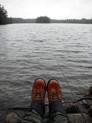
Jamies Pond
Photo by Emmie Theberge
In the conservation of Jamies Pond, everyone involved came out ahead. The former landowner, the Hallowell Water District, was able to get needed funds to develop a deep well-water source for its customers. By selling its land for less than the appraised value, the District helped make it affordable to those who sought to protect it. The Land for Maine’s Future program contributed half the project cost, matched by contributions from the City of Hallowell and numerous local citizens. Now the Maine Department of Inland Fisheries and Wildlife (IF&W) manages a 550-acre area surrounding Jamies Pond where area residents and visitors can enjoy outdoor recreation year-round. The 107-acre pond supports a healthy population of gamefish and other species, making it a popular destination for fishing. In summer and fall, people often walk on the uplands and canoe on the pond, returning in winter to cross-country ski and skate. An excellent trail system on the property enables hikers and skiers to enjoy views of the pond and stream, and to visit an historic dam site.A map of Jamies Pond is posted on the IF&W website.
Closest Town
Hallowell
Activities
Bird & other wildlife watching, hiking, snowshoeing, cross-country skiing, hunting, fishing, canoeing, and kayaking (Note: no swimming allowed in Jamies Pond)
Region
Central Maine Lakes District – Kennebec, Androscoggin
Acres
550
Directions from nearest town
DeLorme Maine Atlas and Gazetteer Map 12, C-4. From Hallowell, take Central Street uphill out of town, bearing left a mile after crossing I-95, then right shortly thereafter onto Outlet Road (at the three-way intersection). Proceed another .75 miles, passing Maple Hill B&B, and bear right onto the rough, dirt Jamies Pond Road (Meadow Hill Road in the Atlas). Proceed another half mile to the left turnoff marked with a boat launch sign, going downhill to the parking area. Trails lead off from both sides of the parking lot. A kiosk with trail maps is on the right trail (facing the pond).


