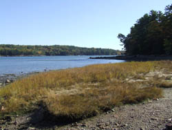
Dodge Point – photo by Allison Childs Wells
Dodge Point slopes gently down from a 240-foot height of land to the Damariscotta River, where the land drops off precipitously in places–offering views downriver that extend for miles. The property is rich in ecological and historical values as well as scenic beauty. The 508-acre peninsula has old growth trees, several important plant communities, Native American shell heaps, and the site of a brick-making operation from the late 1800s. At that time, there were 30 brickyards in the vicinity that employed roughly 200 people.
Today the local economy is more reliant on oyster farming which occurs at many sites along the lower Damariscotta River. These farms benefit from the land on Dodge Point being undeveloped as it contributes no runoff pollution that might diminish the river’s high water quality.
The Land for Maine’s Future (LMF) program funded the initial purchase of Dodge Point, with significant contributions from Maine Coast Heritage Trust, the Damariscotta River Association (DRA), and the Maine Coastal Program. Other partners in the collaborative effort included the sellers, who offered the property at a price well below the appraised value, and the brokers who reduced their commission on the sale. Acquisition of a nine-acre addition followed, with support from the DRA, Maine Department of Conservation, and LMF program. DRA continues to assist the Maine Bureau of Parks and Lands in managing Dodge Point. Four loop trails span the property, with the longest (the “Shore Trail”) being 2.8 miles. In summer, visitors can borrow a “Discovery Trail map” from the kiosk that offers a self-guided tour, providing a chance to learn about 27 different plant species en route. In winter, ice skaters often frequent the pond.
Closest Town
Newcastle
Activities
Bird & other wildlife watching, clamming, hiking, snowshoeing, cross-country skiing, dog walking (on leash), hunting, fishing, canoeing, and kayaking
Region
Midcoast Maine – Sagadahoc, Lincoln, Knox, Waldo
Acres
508
Directions from nearest town
DeLorme Maine Atlas and Gazetteer Map 7, B-3. From Newcastle, turn onto Business Route 1 south by the Newcastle Square Church and take another left, in .5 miles, onto River Road. At the fork .5 miles down the road bear left and stay on River Road another 2.5 miles, until reaching the parking and kiosk on your left. Visitors also can arrive by boat and a public dock is provided.


