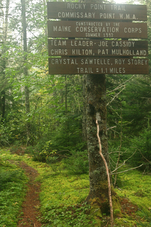
Commissary Point lies at the head of Whiting Bay, just across the water from Tide Mill Farm — a 1,500-acre property protected by an easement that the State purchased with a Land for Maine’s Future (LMF) program grant. Another LMF grant enabled the Maine Department of Inland Fisheries & Wildlife (IF&W) to acquire Commissary Point, and that purchase spurred two adjoining acquisitions, creating a 433-acre wildlife management area with eight unbroken miles of shoreline.
The protection of these properties, in one of the state’s most wildlife-rich regions, has helped Maine to implement the North American Waterfowl Management Plan, a treaty developed between Canada and the United States to protect significant bird habitat. The upland portions of Commissary Point provide feeding, roosting and nesting habitat for numerous bald eagles, while the tidal flats support thousands of resident and migratory waterfowl.
IF&W now works to maintain and restore the diverse mix of open fields, orchards, thickets and woods that characterized this landscape when it was still an active saltwater farm – keeping a diverse array of habitats to meet the needs of varied species.
A detailed trail map and write-up is available in the regional Cobscook Trails guidebook, available at area businesses and through the Downeast Coastal Conservancy.
Closest Town
Edmunds Township
Activities
Bird & other wildlife watching, clamming, hiking, snowshoeing, cross-country skiing, hunting, and worming
Region
Downeast Maine – Hancock & Washington
Acres
250
Directions from nearest town
DeLorme Maine Atlas and Gazetteer Map 27, B-2. From Route 1 in Trescott, take Route 189 1.8 miles east. Turn left onto Commissary Point Road (dirt) by a weathered clapboard house (on right). Travel 4/10ths of a mile down this road to where the access road comes in by a cape-style house (on the right). The parking area (for 2-3 vehicles) and trailhead is one-tenth of a mile beyond the house.


