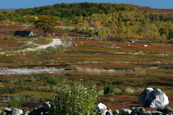
With roughly 360 acres of blueberry fields in active management, Clarry Hill plays an important role in the midcoast blueberry industry. Its high elevations, with expansive views out to the Camden Hills and Western mountains, have made it a target for development as coastal growth and new home construction migrate inland. Subdivision and development of the fields around Clarry Hill would hurt the regional economy, by diminishing the critical mass of midcoast blueberry operations needed to supply processors. If house lots began overtaking the fields on Clarry Hill, many blueberry farmers throughout the region could lose their market and be forced to leave the land fallow or sell it.
To protect both the agricultural and recreational values of Clarry Hill, the Medomak Valley Land Trust (now part of the Midcoast Conservancy) sought help from the Land for Maine’s Future Program, the USDA Farm and Ranch Land Protection Program and other sources to acquire agricultural easements on key lands in the vicinity. The first phase of this multi-year project encompassed 242 acres, including the upper reaches of the hill and the watershed of Storer (Little Medomak) Pond, a popular local swimming hole and skating pond. Yet to be protected is the open summit, which at 643 feet affords panoramic views extending from the White Mountains to Penobscot Bay. Readily accessible by car and foot, it draws hikers, hunters, cross-country skiers, and snowmobilers. Birdwatchers come to observe the annual migrations of hawks, shorebirds and migratory songbirds as well as the resident grassland birds, including the threatened upland sandpiper.
In 2001, the Maine Outdoor Heritage Fund granted $40,000 to this project, recognizing it as the most important grassland habitat in the Midcoast. The Maine Department of Agriculture and the Medomak Valley Land Trust hold easements protecting 719 acres (including the entire watershed of Storer Pond, the headwaters of the Medomak River).
Please note: On private farms protected with Land for Maine’s Future Program support, public access is by landowner permission only. Please see the icons to determine allowed uses and follow any guidance posted on the property. For more information on how to obtain landowner permission, email Stephanie Gilbert at the Maine Department of Agriculture, Conservation and Forestry.
Closest Town
Union
Activities
Hiking, cross-country skiing, snowshoeing, hunting, bird & other wildlife watching, snowmobiling
Region
Midcoast Maine – Sagadahoc, Lincoln, Knox, Waldo
Acres
242
Directions from nearest town
DeLorme Maine Atlas and Gazetteer Map 14, D-1. From Union, head west on Route 17, taking your first left onto Clarry Hill Road. There are no designated trails on the hill at this time, although there are some roads among the blueberry fields.


