The fifth, sixth, and seventh grade GATES (gifted and talented) students from Loranger Memorial School are working together on this project with help from their teacher, Mrs. Nye. The Natural Resources Council of Maine (NRCM) is helping us by providing a grant that we will use to go on field trips to local trails in order to make the map, which will be used in a brochure we will print, with trail descriptions. This brochure will be distributed within the community.
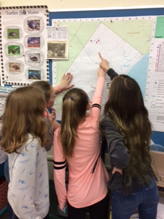
Locating trails on a map of Old Orchard Beach. Students are pointing to Milliken Mills, where we researched American chestnut trees last year.
We are going to work with Kimbark Smith and Mr. Fox from the Old Orchard Beach (OOB) Conservation Commission, who help conserve and protect nature in OOB. We will look for invasive species and report what we find to the Conservation Commission. We will also investigate a vernal pool and look for eggs of amphibians. At the end of the project, we are going to take students from some younger classes on the trails so that we can teach them about the trail features.
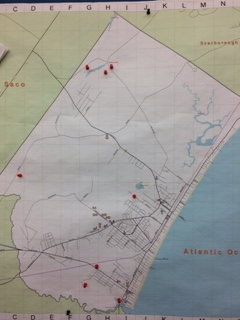
Map of trails we plan to study, indicated by red pins.
For our project, we are going to visit eight trails in Old Orchard Beach, including Ocean Park and the Eastern Trail, to make a descriptive trail map. OOB residents and tourists might decide to visit and walk on the trails once they know where they are and what they may see on them. We are going to observe living things and ecosystems, and investigate the trail terrain, asking question such as is it rocky? Can you ride your bike on it? Is it safe for small children? Can you walk your dog on it?
We will use Google Maps to create a map with labeled trailheads and parking information. When people arrive on the trails, they will see the trail maps in the kiosks at each trail and be able to read information about the natural history and unique features of each.
We will put the map and trail information on a pamphlet that we can put in the brochure racks at grocery stores, the train station, the Chamber of Commerce, the town hall, libraries, and trail kiosks. We are going to get the maps printed on special water-resistant paper so that people can explore in all weather! We will also post the map on the Conservation Commission website and send it to students and families along with the school newsletter.
by Casey, Kailee, Maddy, Savannah, and Mrs. Nye
Our classroom door with our NRCM sticker!


Leave a Reply