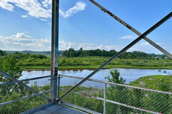
Scarborough Marsh Wildlife Management Area, Gervais Parcel. Photo by Peggy Pennoyer, courtesy of Friends of Scarborough Marsh
In 2009, the Maine Department of Inland Fisheries and Wildlife (MDIFW) purchased this 46-acre panel, stretching along Mason Libbey Road adjacent to Dunstan River, to add to the Scarborough Wildlife Management Area. The property adds additional land to the popular 3,200-acre wildlife management area, and also protects land that was affected by the 1996 Julie N. oil spill on the Fore River in Portland. The piece was purchased from the Gervais family of Scarborough. Since then, the area has benefited from three other acquisitions.
Scarborough Marsh is the largest contiguous marsh system in the state. It makes up 15% of Maine’s tidal marsh area, which is significant given that marshes make up only 0.4% of Maine’s wetland acreage. According to MDIFW, almost three-quarters of water-dependent birds in Maine are found at Scarborough Marsh. The marsh is also nestled within 1.5 miles of several nationally significant seabird resting islands: Stratton Island, sizeable beaches for breeding birds, and additional land protected by the Scarborough Land Trust. The Gervais Parcel is managed by the land trust in partnership with the Friends of Scarborough Marsh. The marsh is home to rich biodiversity, including several rare species such as salt-hay saltmarshes, dune grasslands, the pitch pine bog, and pitch pine dune woodlands.
Closest Town: Scarborough, Cumberland County
Activities: Canoeing, kayaking, bird watching, clam digging, fishing, hunting, wildlife watching
Region: Southern Maine
Acreage: 46
Directions:
From Route 1 South: Head southwest on US-1 South. Turn left onto Lincoln Avenue. In 0.4 miles, turn right onto Washington Ave. Drive 0.1 miles, then turn left onto Manson Libby Rd. The entrance to the Gervais Property Marsh Observation Tower will be on your right in 0.3 miles.
From Route 1 North: Head northeast on US-1 North toward Southgate Rd, then turn right. Drive 0.3 miles, and then turn right onto Manson Libby Rd. The property is 0.4 miles down the road on the right.


