Photo by Allison Childs Wells
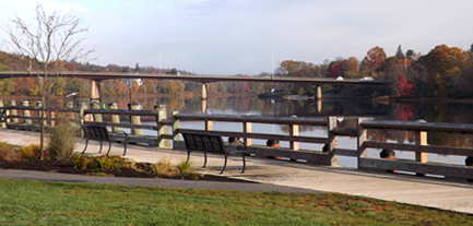
The City of Gardiner acquired land by the mouth of Cobbosseecontee Stream in its historic district that doubles the amount of publicly accessible river frontage in the 10 surrounding towns that border the Kennebec. This 2-acre parcel triples the size of Gardiner’s waterfront park by linking the heavily used boat launch with another State-owned parcel, making an 11-acre waterfront park with a half-mile of river frontage.
The City of Gardiner had identified this key parcel in its 1999 City Downtown Revitalization Plan because it held great potential both to enhance boating opportunities and provide a picnic area with an outdoor pavilion for concerts and festivals. Learning that the land would soon be listed on the open market, the City moved quickly to acquire it. Timely help from the Land for Maine’s Future program, the Department of Conservation, Gardiner Savings Institution, and the Gardiner Rotary Club enabled the City to secure the purchase.
The City has added parking by the boat launch for vehicles and trailers, and constructed a canoe/kayak launch and fishing platforms (which make the site handicapped accessible). The southern section of the newly expanded park, with 5.5 acres of undeveloped State-owned frontage, will serve as a nature study area and outdoor classroom for area students.
Closest Town
Gardiner
Activities
Bird & other wildlife watching, hiking, snowshoeing, cross-country skiing, dog walking (on leash), fishing, trailer boat access, mountain biking, canoeing, and kayaking
Region
Central Maine Lakes District – Kennebec, Androscoggin
Acres
35
Directions from nearest town
DeLorme Maine Atlas and Gazetteer Map 12, C-5 and Map 21, D-2/3. Gardiner’s waterfront is located at the entrance of Depot Square, off Main Avenue in Downtown Gardiner. The Shawmut dam site is located off Route 201, approximately 2 miles north of Turnpike exit 36. More precise directions are available from IF&W.
Upstream along the Kennebec, just north of Waterville, the Land for Maine’s Future program helped fund acquisition of another site that offers easy access to an extremely productive fishery for brown trout and rainbow trout. Anglers frequent this site just below the Shawmut Dam throughout the year, coming from near and far. The tailrace beneath the dam is shallow enough for wading yet broad enough to accommodate many anglers at once. Until the State’s purchase of two riverfront parcels (totaling 33 acres), this longstanding tradition depended upon the tacit permission of private landholders — access that could be revoked at any time or lost upon sale of the land. The Maine Department of Inland Fisheries & Wildlife now manages the Shawmut dam site in Fairfield. Please note: only the wildlife observation and fishing icons are applicable to the Fairfield site.


